When hurricane season is in full swing, the news can be difficult to parse. What’s the difference between a hurricane and a tropical cyclone, after all, and what on Earth is an eye wall replacement cycle? Here’s your Scientific American guide to the terms used to explain the science of hurricanes in the Atlantic Ocean—everything you need to know to parse what’s happening when tropical systems are brewing.
READ MORE: How to Decode a Hurricane Forecast
Life Cycle of a Storm
On supporting science journalism
If you’re enjoying this article, consider supporting our award-winning journalism by subscribing. By purchasing a subscription you are helping to ensure the future of impactful stories about the discoveries and ideas shaping our world today.
Every hurricane comes from modest beginnings—often just a patch of the atmosphere over a particular spot in the ocean that meteorologists believe could have the makings of a storm. These areas are called invests, which is just short for the “investigation” scientists undertake, using computer models and other tools, to understand whether the disturbance poses any risks—many disturbances turn out not to.
On the way to becoming a hurricane, storms typically move through several life stages long before most of us ever hear about the situation. The first stage is a tropical wave, or easterly wave, which is an area of relatively low pressure in the atmosphere. Low-pressure regions pull warmer, wet air in toward them and then foist it upward. That air eventually rises far enough to cool and create clouds and thunderstorms—a process called convection. In the Atlantic Ocean, meteorologists track about 60 tropical waves each year, but the majority never become hurricanes.
Tropical waves and a few other types of weather phenomena are part of the group called tropical disturbances. These systems are typically 100 to 300 miles wide, and their defining feature is that their winds do not swirl around a central point.
When storm systems do develop circularly swirling cloud formations, they become tropical cyclones. Tropical cyclones need to meet a host of criteria: they have a higher temperature at their center than surrounding air, they form over tropical or subtropical water, they contain strong thunderstorms, and their winds circle a defined central point at any speed. (A system can also be identified as a potential tropical cyclone, which indicates that a storm is not yet a tropical cyclone but may bring tropical storm or hurricane conditions to land areas within three days.)
Within the category of tropical cyclones, there are different classifications of storms based on maximum sustained surface wind speeds. In a tropical depression, surface winds move at no more than 38 miles per hour; a tropical cyclone with peak sustained surface wind speeds that range from 39 to 73 mph is a tropical storm.
Systems receive a name when they reach the status of a tropical storm, which is why tropical storms and hurricanes are also sometimes collectively referred to as named storms. These names are selected by the World Meteorological Organization (WMO), which maintains six alphabetical lists of names each for the Atlantic and eastern North Pacific basins and uses one list per year in a six-year cycle. Names are replaced after they have been used for an individual storm that proved to be particularly deadly or otherwise damaging.
READ MORE: Why Hurricane Names Are Retired
Once a storm contains surface winds traveling at more than 74 mph, it becomes a hurricane if it is in the Atlantic or the eastern Pacific oceans and a typhoon if it is in the northwestern Pacific Ocean.
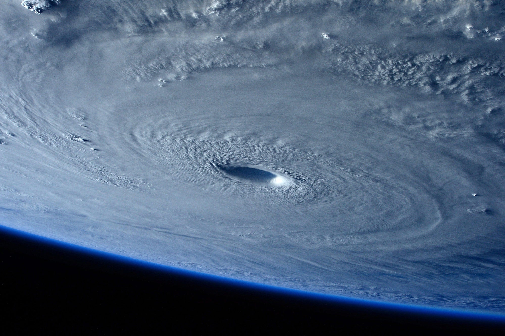
View from the International Space Station of the massive Category 5 Typhoon Maysak as it approached the Philippines on March 31, 2015.
Hurricanes and typhoons are both broken into five numbered categories, which are collectively called the Saffir-Simpson Hurricane Wind Scale. Just like the distinction between tropical storms and hurricanes, these hurricane categories are based on the maximum sustained surface wind speeds: In Category 1 hurricanes, these winds reach speeds of 74 to 95 mph. In Category 2 storms, they reach speeds of 96 to 110 mph. Category 3 winds hit 111 to 129 mph. Category 4 speeds are 130 to 156 mph. And Category 5 winds exceed 157 mph. The term major hurricane refers to a storm of Category 3, 4 or 5. Typhoons are called supertyphoons if their winds exceed 150 mph.
READ MORE: Hurricane Categories Don’t Capture All of a Storm’s True Dangers
There’s one more categorization system to be aware of for departures from the standard definition of a tropical cyclone. Extratropical cyclones are storms that gain their energy from temperature differences between warm and cold air masses that abut horizontally in the atmosphere instead of the convection that drives tropical systems. These can include blizzards and nor’easters but also tropical storms that travel far enough north to be caught up in a front—which is a transition zone between air masses with different traits—and become asymmetrical. These storms can still retain very fast winds that are equivalent to those in tropical storms and hurricanes.
Subtropical cyclones are a sort of in-between state that mixes characteristics of tropical and extratropical cyclones: either the warm, convective core of a tropical storm and the asymmetrical structure of an extratropical one or the symmetrical structure of a tropical storm with the cold, temperature-difference-driven core of an extratropical one.
In general, storms that were formerly tropical but no longer meet enough criteria of the definition are referred to as post-tropical.
Hurricanes are historically most common during hurricane season, which runs from June 1 to November 30 in the Atlantic Ocean basin, although storms can form outside this period under unusual circumstances. The peak of the Atlantic season occurs from about late August to early October. The eastern Pacific Ocean season begins on May 15 and also ends on November 30.
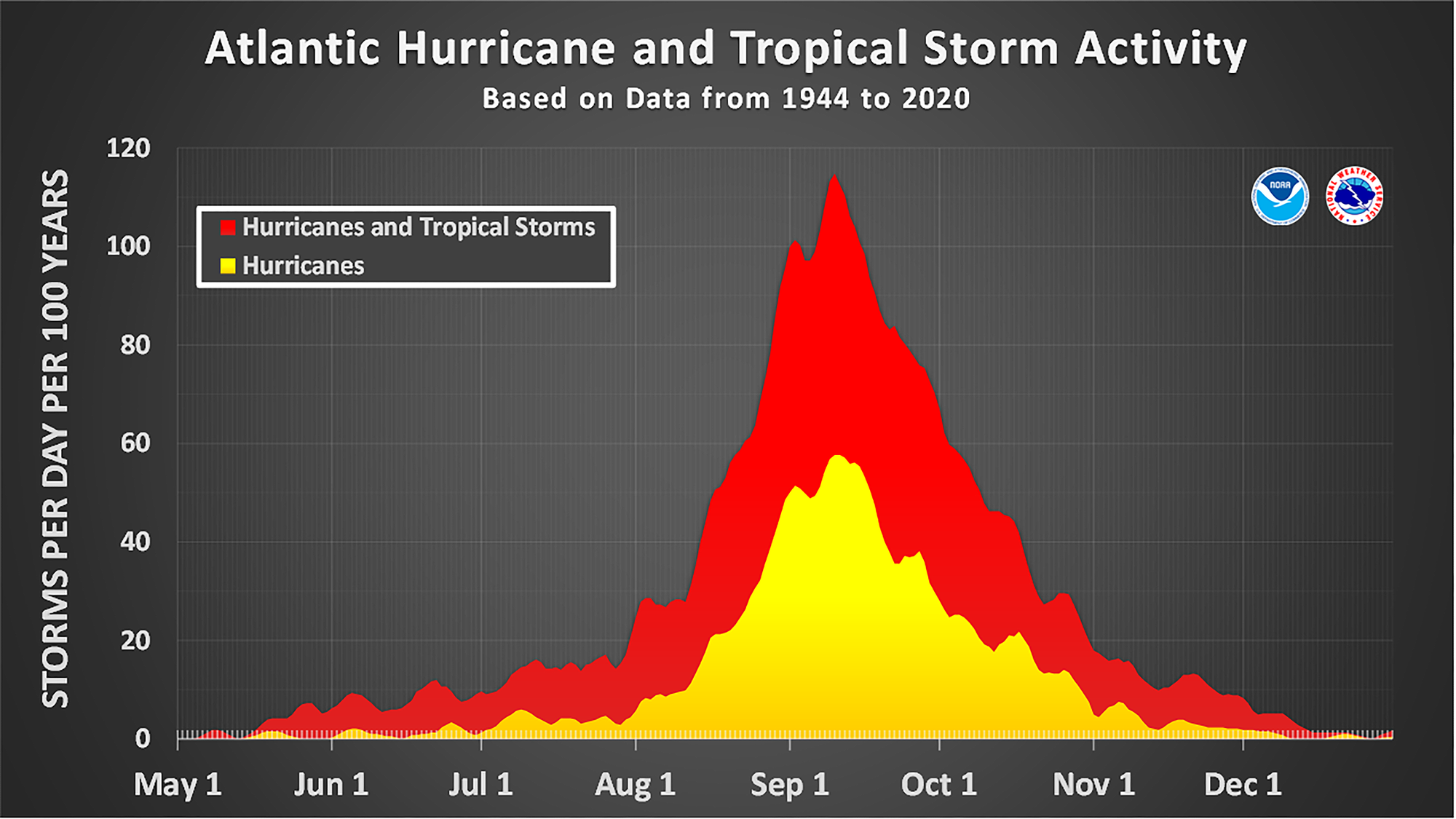
The number of named storms and hurricanes that have historically occurred in the Atlantic basin on each calendar day between May 1 and December 31. Hurricanes appear in yellow and tropical storms appear in red. The data have been smoothed using a 5-day running average centered on each calendar day. The chart is based on data from the 77-year period from 1944 to 2020 (starting at the beginning of the aircraft reconnaissance era) but normalized to 100 years. The official hurricane season for the Atlantic basin is from June 1 to November 30, but tropical cyclone activity sometimes occurs before and after these dates, respectively. The peak of the Atlantic hurricane season is September 10, with most activity occurring between mid-August and mid-October.
Hurricane Structure and Behavior
Two key phenomena can influence how large and strong a tropical storm or hurricane becomes. The first factor is sea surface temperature, which is the temperature of water at the surface of the ocean. Where sea surface temperature is higher, storms grow stronger because warm water feeds a storm more energy for convection than cooler water does.
The second factor is wind shear, which describes the variation in wind speed and direction at different heights in the atmosphere. Higher wind shear can tear apart a storm’s structure or prevent it from getting as strong in the first place.
READ MORE: Meet Wind Shear, the Phenomenon That Can Rip a Hurricane Apart
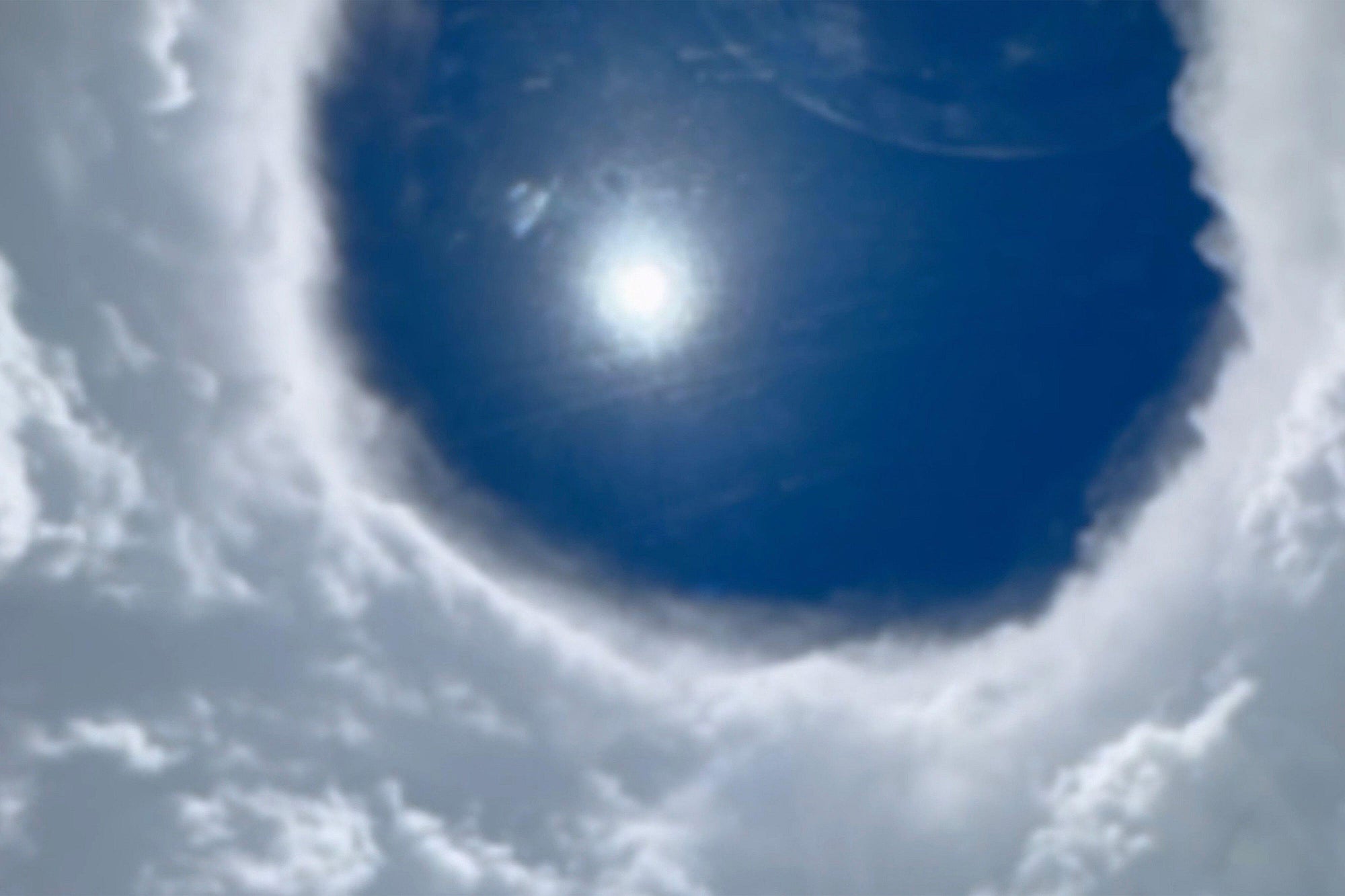
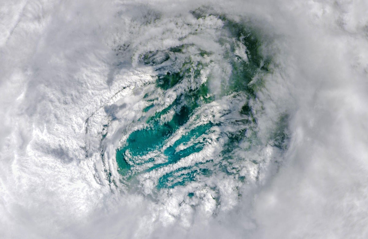
A view from a Hurricane Hunters monitoring flight that traveled through the eye of Hurricane Erin on August 16, 2025.
Speaking of structure, tropical cyclones have three main parts. The eye is the calm, cloudless heart of the storm. Here, the atmospheric pressure, or barometric pressure, is at its lowest. Surrounding air moves toward this low-pressure region, but Earth’s spin diverts it, causing the formation of an eye wall, a circle of strong thunderstorms around the eye. Additional rainbands of clouds and thunderstorms surround the eye wall in a spiral shape.
LISTEN: Follow a Hurricane Expert into the Heart of the Beast
Sometimes a rainband can develop into a second eyewall surrounding the core of a storm and absorb the original eye wall in a process called an eye wall replacement cycle. This temporarily weakens the storm, reducing its peak wind speed. But if the storm remains over warm water, the winds can speed back up again. More dangerously, eye wall replacement results in a larger storm that can inflict high winds and heavy rains on a larger geographical area.
Another phenomenon that can make storms more dangerous is rapid intensification, which occurs when a storm’s peak sustained wind speeds increase by at least 35 mph within a period of 24 hours. Rapid intensification is more likely when sea surface temperatures are high and wind shear is low, as well as when barometric pressure at the heart of the storm is low. When meteorologists are unable to predict a storm’s rapid intensification, people in its path can be left underprepared for the effects that ensue.
READ MORE: New Hurricane Forecasts Could Predict Terrifying Explosive Intensification
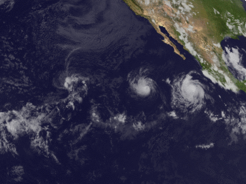
GOES-16 satellite imagery over the eastern Pacific Ocean from July 25 to August 1. Hurricane Irwin on the left collided with Hurricane Hilary on the right; the two merged before fading out over the ocean in an example of the Fujiwhara effect.
Typically, tropical cyclones are individual phenomena. But occasionally, storms come close enough to each other to interact in what’s known as the Fujiwhara effect. The event is named for Sakuhei Fujiwhara, the scientist who theorized it in 1921, when he posited that two vortices spinning through fluid could come close enough to each other to orbit a common central point. In the context of tropical cyclones, this can occur when storms come within around 850 miles of each other, although the sizes of the storms dictate when they begin interacting.
Hurricane Effects
Meteorologically speaking, a tropical cyclone makes landfall only when its center intersects with a coastline. This means that a storm can have serious effects on land without ever actually making landfall.
And a tropical cyclone can come with many hazards regardless of whether it makes landfall. For example, even from hundreds of miles away, a hurricane can cause a dangerous rip current, which is a strong channel of water leading away from a beach.

Buildings sit along the coast line as the rain and storm surge from Hurricane Debby inundate a neighborhood on August 5, 2024, in Cedar Key, Florida.
As a tropical storm moves closer to land, it can create storm surge by pushing a wall of ocean water—as tall as 30 feet when combined with normal tides—toward the coast.
READ MORE: Why Storm Surge Is Dangerous—And Becoming More Frequent
Storm surge is responsible for plenty of a hurricane’s flooding, but so is flash flooding, which is triggered by heavy rainfall, typically within a time frame of just six hours.
READ MORE: What Is a Flash Flood?
In addition to these water-based hazards, tropical cyclones can also spawn tornadoes, although the number of twisters from a particular tropical storm varies dramatically. Typically, such tornadoes occur in a tropical cyclone’s rainbands, away from its core.
For such hazards, the National Weather Service issues two types of alerts. A watch is a milder alert that is typically issued 48 hours in advance: it indicates that hazardous weather is possible. A warning, in contrast, is issued 36 hours in advance and indicates that the weather phenomenon is expected to occur. Both should be taken seriously. If you are subject to either a watch or warning for a hurricane or related weather, be on alert and prepared to respond as directed by local officials.
Although these hazards unfold as a storm arrives, a tropical-cyclone-affected community can continue paying the cost of the event for years after it occurred. Research on excess deaths following hurricanes shows that people continue to die as much as 15 years after a storm hit.