QUICK FACTS
Where is it? Mount Etna, Sicily, Italy [37.75358362, 14.99436372]
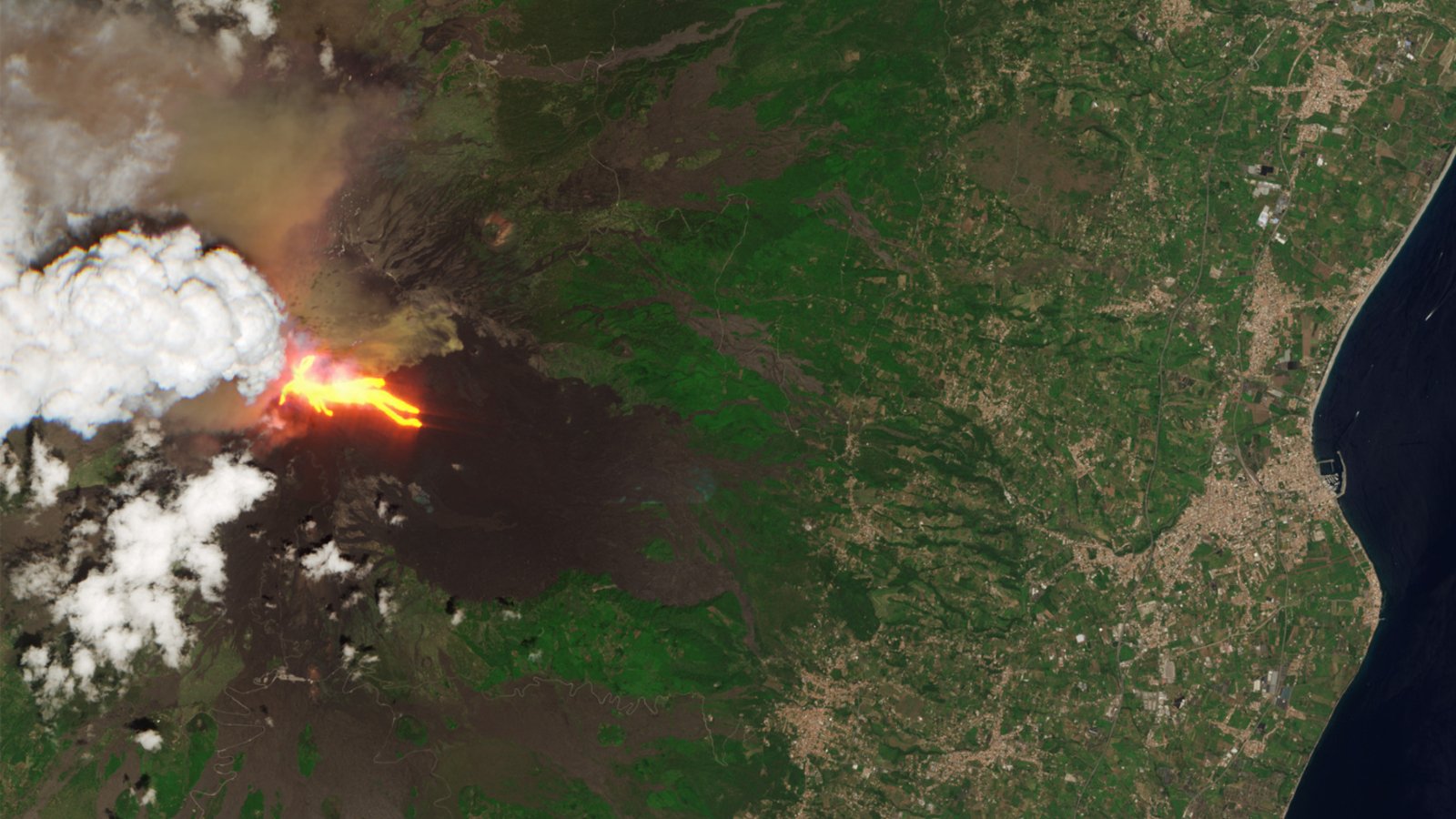
What’s in the photo? A river of lava flows down the flank of the volcano during a major outburst
Which satellite took the photo? Copernicus Sentinel-2
When was it taken? June 2, 2025
Satellite photos have captured a glowing “river of fire” flowing down the flanks of Mount Etna during an explosive outburst that also unleashed a giant plume of ash, smoke and volcanic gases high above the Italian island of Sicily.
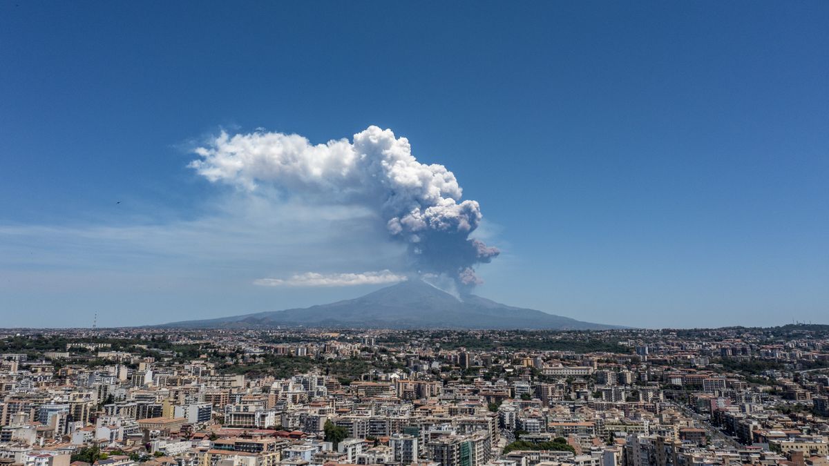
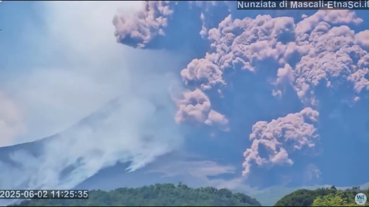
On June 2, at around 11:20 a.m. local time, a giant, superhot avalanche of ash, known as a pyroclastic flow, suddenly exploded from near Mount Etna’s summit and raced down its western flank. Experts think the fast-moving ejecta was unleashed when a section of the volcano’s caldera wall collapsed. The surprise outburst forced tourists to scramble for safety, but nobody was injured or killed.
During the eruption, a volcanic plume was also unleashed that towered up to 4 miles (6.5 kilometers) above Europe’s largest active volcano. The plume was made of sulfur dioxide, which is toxic and can be deadly in high concentrations. However, the eruption ceased within six hours, meaning that the plume and its effects on the environment were short-lived.
One of the European Union’s Copernicus satellites was passing above Sicily during the eruption and captured a stunning shot of a lava flow winding down the mountain in the opposite direction to the pyroclastic flow. The fiery river had gone largely unnoticed as people’s focus was drawn to the towering plume. But the molten rock did not reach any populated areas.
In the image, the glowing lava is surrounded by dark patches of ground stretching toward the Mediterranean coast, which could be mistaken for a giant shadow being cast by the 11,013-foot-tall (3,357 meters) mountain. This dark patch is actually made up of fossilized magma left behind from previous eruptions.
Related: See all the best images of Earth from space
Chris Hadfield, a retired astronaut and former commander of the International Space Station (ISS), shared the satellite image on the social platform X on June 3. “It’s wild to see a volcano erupting from space,” Hadfield wrote. “I saw several during my six months [on the ISS], but Mt Etna’s violence yesterday was crazy.”
The sight of the lava flowing from the volcano’s summit is a reminder that “we live on a thin bit of cooled crust over a liquid rock inferno,” he added.
Explosive outbursts
Mount Etna has been erupting intermittently since November 2022, according to the Smithsonian Institution’s Global Volcanism Program. But for the majority of this time, the mountain has been relatively quiet, occasionally rumbling, spitting up small amounts of lava or coughing out giant, perfectly circular rings of smoke.
But this recent eruption was the volcano’s most explosive outburst since 2021, during the volcano’s previous eruptive phase, which lasted between September 2013 and June 2022. During that previous phase, the volcano grew more than 100 feet (30 m) in six months after experiencing 50 back-to-back outbursts between March and August 2021.
Some outlets initially reported that the most recent outburst was the largest since 2014. However, this was later shown to be incorrect.
Mount Etna has had more than 30 different eruptive phases over the last century, totalling around 76.5 years between them. The volcano’s unusually high level of activity is due to its position on the boundary between the African and Eurasian tectonic plates, as well as a high level of volcanic gases that accumulate within its magma chamber.
Its outbursts are frequently captured from space: In March 2021, Landsat satellites captured a striking picture of lava flowing down the mountain’s flanks; and in February 2022, astronauts on board the ISS snapped a photo of a volcanic plume rising above Sicily.