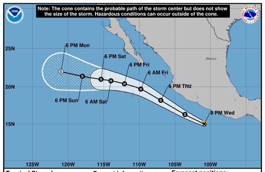
A day after forming south of Mexico in the Pacific, Tropical Storm Ivo is expected to continues dumping considerable rain on coastal Mexican states throughout Thursday and Friday. The storm could briefly strengthen into a hurricane Friday evening.
At noon Thursday Mexico City time, Mexico’s National Water Commission (Conagua) located the storm at 130 km (80 miles) south of Playa Pérula, Jalisco, and 700 km (435 miles) southeast of Cabo San Lucas, with maximum sustained winds of 75 km/h (47mph).

The Miami-based National Hurricane Center (NHC) reported said Ivo could produce total rainfall of roughly 100 mm (3.9 inches), with isolated maximum totals of 150 mm (5.9 inches), across portions of Mexico’s Pacific Coast. Conagua predicted “intense rainfall” (75 to 150 mm, or 3 to 5.9 inches) in the states of Jalisco and Nayarit, as well as heavy rains in Michoacán and Colima (50 to 75 mm, or 2 to 3 inches).
Ivo was moving quickly toward the west-northwest — generally parallel to Mexico’s Pacific Coast — at roughly 39 km/h (24 mph), but was expected to veer westward before hitting the Baja California Peninsula. It is likely to dissipate by the weekend as it turns away from the coast.
However, Ivo is stirring up life-threatening surf and rip-current conditions as maximum sustained winds have increased to near 75 km/h (45 mph) with higher gusts. Conagua issued a warning related to the heavy surf for Jalisco, Colima and Michoacán (waves up to 5 meters or 16.4 feet in height) and Guerrero (4-meter or 13-foot waves).
Area residents and businesses along the southwestern coast are advised to monitor Ivo’s progress and adhere to advisories issued by local civil protection agencies. The rainfall could result in an elevated risk for flash flooding in the states of Guerrero, Michoacán and Colima.
Ⓜ️📺🚨 Alerta en las costas de #Oaxaca y #Guerrero por formación de la tormenta tropical #IVO
Se ha registrado la formación de la tormenta tropical Ivo, la cual se desplaza al oeste-noroeste en paralelo a las costas del Pacífico. Aunque aún no hay avisos oficiales de alerta… pic.twitter.com/UB9yi8B5Zo
— Sofy Valdivia (@sofyvaldivia) August 7, 2025
Tropical-storm-force winds extend outward up to 55 km (35 miles) from the center and Ivo is likely to strengthen to near hurricane strength by late Friday. The storm is also expected to produce winds of 40 to 50 km/h (25 to 31 mph) with gusts of 60 to 80 km/h (37 to 50 mph) in the northern Gulf of California.
Conagua said Ivo’s high-altitude cyclonic circulation will combine with humid air from the Gulf of Mexico and the Pacific Ocean, as well as a low-pressure trough over the southeast of the country, to cause heavy wind and rains elsewhere in the country.
Heavy rains of 25 to 50 mm (1 to 2 inches) are expected in the northern states of Chihuahua, Durango, Zacatecas and Aguascalientes, as well as on the Gulf side in the states of Campeche, Veracruz and Tabasco.
Gusts of 40 to 60 km/h (25 to 37 mph) could occur in the northern states of Sonora, Sinaloa, Chihuahua, Coahuila, Nuevo León, Durango, San Luis Potosí, Zacatecas and Aguascalientes. Additionally, Ivo could produce dust storms in Baja California and Baja California Sur.
With reports from El Financiero, El Universal, Newsweek and Conagua